
Thermal Energy Resource Modelling and Optimisation System
Heat and cold network planning, in a web browser.
THERMOS maps thermal energy demand at address level and designs district heating and cooling networks against it. Give it an area and a set of costs, and it returns an optimised network in minutes rather than weeks.
What it does
Decision support for heat networks
Working out where a heat network should go is normally slow and expensive. Demand data is assembled by hand, candidate routes are drawn on a map by eye, and each one is costed separately. Options that nobody thought to draw never get costed at all.
THERMOS takes a different route. It considers every building and every possible pipe run in an area at once, and returns the network that best satisfies the objective you set, whether that is lowest cost, best return, a carbon target, or a list of buildings that have to be connected. Re-running it with different assumptions takes seconds.
Address-level mapping
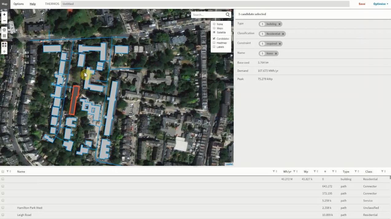
Build a heat or cold map for anywhere in the world. THERMOS takes building footprints and the street network from OpenStreetMap, or reads your own GIS layers where you have better data.
Demand estimation
Where metered consumption is not available, demand is estimated from building geometry, use and location. Feed in LIDAR, floor areas or measured demands and the estimates tighten accordingly.
Network optimisation
The model decides which buildings to connect and which streets to dig, subject to your constraints: required and forbidden connections, alternative individual heating systems, and the counterfactual of no network at all.
Realistic costs
Pipe and excavation costs vary with diameter. Heat losses to the ground are modelled explicitly, alongside connection costs, plant capital, heat sales revenue and monetised emissions.
Supply modelling
Size plant and thermal storage against an hourly demand profile, so heat pumps, CHP, stores and time-varying tariffs can be tested properly rather than reduced to a single annual figure.
Export and share
Results come out as GIS layers and tables. Everything happens in one web application, so consultants, clients and other stakeholders can look at the same model instead of exchanging versions of a spreadsheet.
Cooling too
Cold networks work the same way
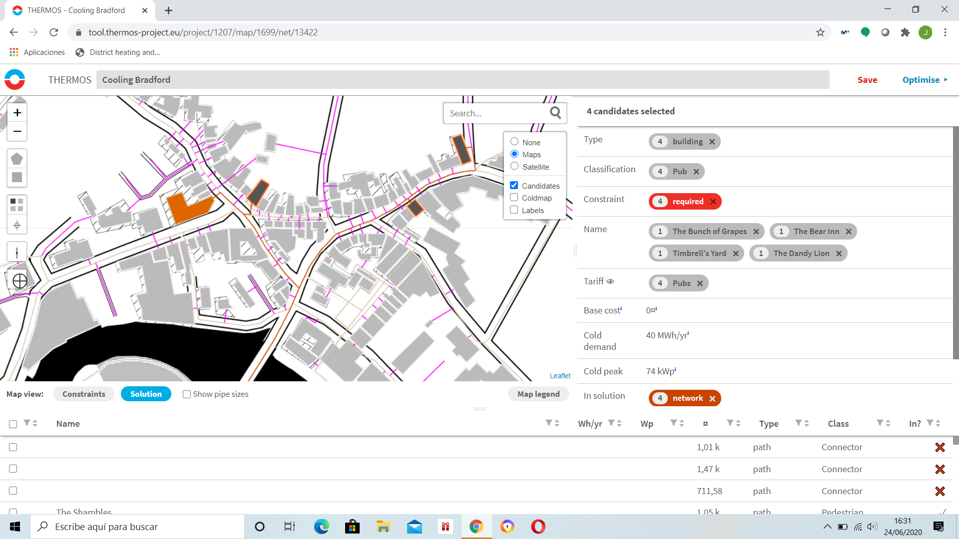
District cooling is modelled on the same basis as heat: the same mapping, the same demand estimation, the same optimisation. Cooling demand, peak cooling load and cold network costs are first-class inputs rather than an afterthought.
That matters more each year. Cooling loads are rising across Europe, and the places where a cold network makes sense are not always the places where a heat network does.
Why planners use it
Quick enough to ask better questions
Fast and flexible
A case takes minutes to set up and seconds to re-run. Rather than costing two or three fixed options, you can sweep across tariffs, carbon prices, network temperatures and build phasing, and find out where the answer actually changes.
Consistent and defensible
One documented model applied to every location and every scenario, so results are comparable between studies. Spatial density rules of thumb, applied by hand, are neither repeatable nor easy to challenge afterwards.
Open
The source code is public and the modelling method is documented. How a number was produced is available to the people who have to act on it, and to anyone reviewing their work.
Who uses it
Anyone with a local energy planning remit and a web browser
THERMOS was built with each of these groups involved in its design and testing, so that it fits how thermal energy planning is actually done.
- Local and regional government
- District heating and cooling utilities
- Network and property developers
- Consulting and engineering firms
- Energy agencies and ESCOs
- Universities and research groups
Since the research project ended, THERMOS has been adopted by commercial and academic organisations for heat network planning and modelling: feasibility and pre-feasibility studies, zoning work, network expansion appraisal, and teaching. It has not stood still. CSE continues to develop and extend the software as heat network practice and policy move on.
Behind the National Zoning Model
The demand modelling and network optimisation developed in THERMOS form the basis of the UK Government's National Zoning Model, which is used to identify the areas of England where heat networks are the lowest-cost route to decarbonising heat.
The same core that plans a network for one town scales up to a national assessment. Councils, consultancies and government departments end up working from a consistent method rather than incompatible ones.
Where it came from
A Horizon 2020 project, finished in 2021
THERMOS, the Thermal Energy Resource Modelling and Optimisation System, started in October 2016 as a research and innovation project funded by the European Union's Horizon 2020 programme under grant agreement No. 723636.
Eight partners and eight cities, based in the UK, Spain, Poland, Latvia, Denmark, Germany, Portugal and Romania, set out to remove the main practical obstacle to district energy: the time, money and expertise it takes to work out where a network should go, and whether it is worth building. The consortium built address-level heat and cold maps for four pilot cities, repeated the exercise with four replication cities, and used what it learned to specify the software.
Project partners






- Centre for Sustainable Energy, UK (coordinator)
- Imperial College London, UK
- Aalborg University, Denmark
- ICLEI Europe
- Deutsche Energie-Agentur (dena), Germany
- Creara, Spain
- Latvian Environmental Investment Fund, Latvia
- Polish National Energy Conservation Agency (KAPE), Poland
Alongside them, the cities of Granollers, Islington, Jelgava and Warsaw, the Greater London Authority, and Cascais, Alba Iulia and Berlin. An advisory board of district energy, engagement and finance specialists reviewed the work throughout.
| Pilot city | Replication city | Supported by |
|---|---|---|
| Granollers, Spain | Cascais, Portugal | Creara, AAU, ICLEI |
| Islington, UK | London (GLA), UK | CSE, AAU, ICLEI |
| Jelgava, Latvia | Alba Iulia, Romania | CSE, AAU, ICLEI |
| Warsaw, Poland | Berlin, Germany | KAPE, AAU, ICLEI |
By the time the project closed in March 2021, more than 1,400 users from New Zealand to South America had built over 3,000 maps and projects with THERMOS. Rather than let the software lapse with the funding, the partners agreed to keep it running.
CSE's part in it
The project was coordinated by the Centre for Sustainable Energy, an independent national charity based in Bristol, which also wrote the software. CSE's modelling team developed the optimisation engine with Imperial College London, and has maintained and extended THERMOS ever since the project ended.
If you want modelling work done, want the tool to do something it does not currently do, or want to talk about heat networks and zoning more generally, CSE is who to approach.
Source code
Open source, and free to run yourself
THERMOS is published as open source. You can read it, run it on your own server, or build on it.
If you use the public THERMOS system in your work, academic or commercial, you must include this citation:
This work uses results from the THERMOS (https://www.thermos-project.eu) model.
THERMOS was an EU Horizon 2020 funded research project (grant agreement No 723636) coordinated by the Centre for Sustainable Energy.
For more information about THERMOS contact the Centre for
Sustainable Energy (https://www.cse.org.uk).
Contact
Two ways in
Heat network modelling and consultancy
CSE works with local authorities, government and industry on heat network feasibility, zoning studies and area-based heat decarbonisation. If you need modelling done, or want the tool extended for a particular job, start here.
Questions about the tool
For help using THERMOS, questions about accounts, or anything to do with the software itself, email the project inbox.